16th November 2017
Glacial Dust from the Copper River Valley
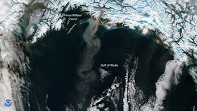
The NOAA/NASA Suomi NPP satellite’s VIIRS instrument captured this plume of glacial dust streaming into the Gulf of Alaska from the Copper River Valley. As glaciers flow, they grind against underlying bedrock, which produces a very fine powder known as “glacial flour” or “rock flour.” Rich in iron, this silty substance often flows into rivers and lakes, giving the water a brown or grey tinge. When water levels are low, the flour dries out on riverbanks and deltas. Winds then lift the dust into the air and can transport it over several hundred miles of open ocean. Researchers are using satellite data to better understand how glacial dust events in the Gulf of Alaska can trigger phytoplankton growth, which affects marine ecosystems in the region.
Although true-color images like this may appear to be photographs of Earth, they aren't. They are created by combining data from the three color channels on the VIIRS instrument sensitive to the red, green and blue (or RGB) wavelengths of light into one composite image. In addition, data from several other channels are often also included to cancel out or correct atmospheric interference that may blur parts of the image.
(Image and details source:NOAA/NASA)
(Image and details source:NOAA/NASA)


No comments:
Post a Comment